Sunday, November 7, 2010

I Need a 14er Fix!!

Early winter has reached parts of the high country.  Still no snow down here in the foothills of the Front Range, though I have heard rumors of it coming later this week.  With the fourteeners all closed down for me until next summer, I have been beginning to plan my climbs for next year. I think I have 7 that I really want to do, with a bonus 2 if I get the chance.

                Mt Sherman  14,036'
                Mt of the Holy Cross  14,005'
                Mt Yale 14,196'
                Mt Princeton 14,197'
                Mt Eolus 14,083'
                Windom Peak 14,082'
                Sunlight Peak 14,059'

Bonus Peaks
                Mt Elbert 14,433'
                Mt Massive14,421'


I am really looking forward to the Chicago basin trip.  We will probably venture down there in late July while Doug's wife is away climbing Mt. Kilimanjaro (he climbed it 3 years ago).  The pictures of the basin are incredible.  And the idea of taking the train in and out adds a little something to the adventure.  I am trying to talk Jon into coming along as well.

Mount Sherman should be a nice warm up for the season.  This is one of two remaining 14ers, that I have climbed before this project started, so I feel as if I need to climb it again.  This time I will be coming in from the west side.  The other re-do is Long's, which I am saving for last.

Mount of the Holy Cross will get me back into the Vail area where I first started teaching 10 years ago.  I have heard that this one is a challenge as it requires going up , over and down Halfmoon pass before climbing once again to Holy Cross.  I am pretty sure that this will be an overnighter as well.

I'll spend the winter working on getting in better shape than last year, and I was happy with the shape I was in last summer.  Work harder in the winter, to make the summer trips easier.  Last winter I did a lifting class, Body Pump, twice a week as well as spinning twice a week too.  This winter I want to add 1 -2 stair climber workout with a weighted backpack.   Probably the 30 pounds I lost helped in making the summer a success as well.  No 30 pounds to lose this winter, but maybe another 10-12 (put a few back on this summer).

Keeping my eye open for a few gear items as well.  A helmet, maybe a new head lamp and I'm always looking for that perfect pack.

Until next summer, have a great winter all.  Get out and play!


Friday, October 22, 2010

Mount Bierstadt & Mount Evans

Mount Bierstadt  & Mount Evans
54/54/8-9
 August 28th, 2010

Bonus time!  I managed to arrange one more trip for the season.  I had not planned trying anymore 14ers this year, but Jon suggested that we should do a 14er, and from there it somehow morphed into 2 14ers.  Unfortunately, during this time I also lost Jon, but Doug agreed to come along.  His presence was reassuring, as he had done the Sawtooth Ridge between Bierstadt and Evans before, which was my planned route.  I had first seen this route, when I picked up Roach's book on 14ers (I think).  It is such a striking line that I knew I would have to do it.
Doug and I drove up after work on Friday and bivied just above the upper parking lot.  The night was warm, and clear and the sky was alive with stars.  I woke up a few times during the night and had to fight off the urge to stare at stars.  Our alarmed chimed at 3:30 a.m. and we were out of the bivies quickly.  The full moon was still up, so we were able to hit the trail with no headlights.
On reflection this may have been a bad idea.  The no headlamps, almost ended our hike before it even really began.  Not it wasn't a trip over a rock or a root, something much more alive.  Doug lead out of the trailhead and within 100 or so yards of starting the trail, we walked passed to large rocks.  Just as Doug got with 15 yards of the rock, they began to move.  With only the moonlight, to see by, we had to do a double take.  As we did the rocks morphed into two moose standing just of the trial.  Doug froze and I began to slowly move backwards.  Sorry Doug, but better you than me.  After some calming words, for the moose and myself, we worked our way through the willows off trail, and around the moose.
The remainder of the way up Bierstadt was uneventful.  The moon provided plenty of light to see by, so we never needed to break out the headlamp.  We did not have anyone pass us on the way up (a first for me), but as we approached the flat before the final push, we had a solo hiker catch up to us.  I decided that I did not get up, at OOOOOOOO to early, to have someone beat me to the summit, so I shifted into high gear and high tailed up the final push to be the first person to summit Bierstadt that day.  Doug quickly joined me.  We snapped a few pictures just as the sun's rays were warming the peak.  From the peak we could see the Sawtooth Ridge, the actual challenge of the day.


The way to the Sawtooth drops off the north side of Bierstadt.  The exit gully from the ridge down to the Sawtooth drops steeply.  We had to pick our way down loose scree, being careful not to slip out.  We roughly followed the cairns marking the route.  We ended up traversing below the crest of the Sawtooth by about 40 yards or so.  This was where the fun really started.  We had to do some route finding, which made the traverse much more interesting.  About half way across the ridge we encountered the gendarme.  We  decide to work our way along the lower eastside of it.  Looking back we probably would have been fine taking the direct route up it. But the lower route provided a great experience.  Once around the gendarme we worked back up to the ridge, where we crossed over to the backside of the ridge. 
This was the side that I had been worrying about.  Even though the trip reports I had read said this section was much easier than it looked, my first glance left me doubting these.  The pictures I saw did not instill me with much confidence.  Doug took off quickly once we reached the west side.  He figured that any hesitation on his part, might have lead to second thoughts.  Once I started this traverse I felt much better.  The trail was not as narrow, or as close to the edges' drop off as I feared.  With each step my confidence grew and I found myself make quick work of this section.  The final stretch up the ledges, is much more solid than it looks from any of the pictures that I have seen. 
For anyone thinking about doing the Sawtooth, I highly recommend it.  It is not nearly as intimidating as it seems from pictures or trip reports.  It truly was the highlight of our trip.  DO NOT pass it up!!!!!!!!!!
Once passed the Sawtooth we worked our way through alpine tundra studded with rock around to the south side of Mount Evans.  Doug and I dubbed this section of the hike as "The Trudge" - " To trudge: the slow, weary, depressing yet determined walk of a man who has nothing left in life except the impulse to simply soldier on. (Chaucer - A Knights' Tale)".  This summed up the traverse along the east side of Mount Evans up to the summit.  Just before the parking lot at the summit, we ran into a small band of mountain goats.  They looked beautiful.  Their coats we already to begin to fill in with the thick, full white coat of fall.
The summit was a little anti-climatic.  With easy access from the parking lot just a mere 100 yards from the summit, anyone a goofy pair of golf shorts can summit a 14er. Yes he was there, but he was a really nice guy.  A few of the folks we talked to had actually hiked up from Summit Lake, first summing Mount Spalding. 

To get off the summit we had to repeat "The Trudge". The second time was almost as bad.  Not hard at all, just tedious and tiring.  Instead of returning back over the Sawtooth, which would of required a really step climb back up the descent gully, we headed down a gully just to the north of the Sawtooth.  Just as we entered this gully, we spotted a band of 14 Big Horn sheep.  This really surprised me, as I would not have imagined big horns and mountain goats living so close together. 
This descent gully was slow going.  Most of it wad steep, lose scree.  It probably took us an hour plus to work our way down it.  I would be interested in seeing what the next gully to the north is like.  It did not look as steep or as rock strewn, at least from a distance.
This gully lead us into the dreaded willows.  From the trip reports I read the willows were the stuff of legend.  But once again I did not find this to be true.  This late in the season there were clear paths worn through them.  I imagine that early season before the paths are worn down it would be tough, slow going, but today they were not too bad.  We did have to go through a few swampy areas, one of which left me knee deep in a mud hole.
We eventually made our way back to the main trail, and we joined by the masses working their way down off of Bierstadt.  I felt a sense of pride and accomplishment knowing that I achieved something today, that many of these folks could not, would not even dreaming of doing.

Saturday, August 21, 2010

Lincoln Group

54/54/4-6

July 31st, 2010


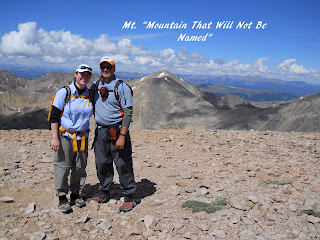
Mt Democrat, Mt Cameron, Mt Lincoln, Mt. Mountain That Shall Not be Named


Round two for the year.  I was not actually sure if I would really get to make this trip; the best made plans of mice and men and all.  With my parents in town for a couple of weeks Karen was able to get away with me for this hike.  This was her first time away from our son, and the first time we were both away from him overnight at the same time.  We left Friday night after work, to avoid having to get up early and make the long drive then hiking.  We missed the turn off in Alma to the Kite Lake trailhead, after turning around we spent a few minutes searching the darkened streets for an almost non-existent street sign.  The road up to the trailhead was pretty bumpy.  Passable is a passenger car, but I'm not promising how your suspension will be once you reach the end.  There were a few tight turns that you would not want to swing to wide on.  There is a small parking fee at the trailhead, but well worth it for the nicely kept bathroom.  We tucked the truck in between the other vehicles already there and hit the hay.

My alarm went off at a quarter to five hoping for an early start.  But with the sky still being filled with night and only one head lamp between us, I decided to snooze a little longer. About 45 minutes later we rolled out of the truck, made breakfast and packed up for the day.  The parking lot was starting to come awake as well.  A few new cars were slowly filing into the parking lot.  We passed a sleeping form in a sleeping bag as well left the trailhead. 

50 yards out of the  trailhead we had a 8 foot stream crossing.  The water was moving really briskly for this late in the year.  Form the crossing the trail headed northward, skirting Kite Lake.  The trail started off fairly level but began climbing at about the half way point.  At the end of the first steep sections were the remains of old mining buildings.  From here the trail made its way across an open bowl beneath Mt. Cameron before beginning to climb up to the saddle between Cameron and Mt. Democrat.  The relatively plentiful remaining water often found its way to the trail, leaving rivulets of water to great us as we climbed higher.

From the saddle between the two peaks we got a great view of Quandary Peak to the north.  With the sky looking nice and blue we left the saddle and headed up to Democrat's summit.  I thought I was able to see the summit from the saddle, so you can imagine my disappointment upon reaching what I thought was going to be the summit only to top out and see the true summit another quarter mile or so away.  The hike to the true summit provided no difficulties.  I was surprised to find a small snow field remaining just past the false summit.  There were about 15 people on the summit (14,148') when we arrived just after 8 a.m..  Already, at this early hour the peak were beginning to get busy.  With a long day ahead of us, we took our quick victory photos and began the  descent back down to the saddle.  If we thought the summit was crowded, the trail was much worse.  We passed a steady stream of hikers on their way up.


Back at the saddle we passed a family with a five year old, who was doing his first 14er.  Hopefully our little one will love the outdoors enough to want to try one at such as early age.  He is already showing promise though.  After another quick breathers we headed up towards Cameron.  The trail turned out not to be as bad as it looked.  A steady climb found us at Cameron's "summit" just a little over an hour after summiting Democrat.  The summit was very anticlimactic.  Really nothing more than a football field size scattering of small rocks.  Even though its elevation is 14,238', higher than Democrat, it does not count towards the official 54 due it the lack or elevation change to get to it.  Climb your own climb I guess.  Cameron does serve as the gateway to Mt Lincoln.


To reach Lincoln, we scooted down a short, lose scree slope on Cameron's east side to a small level area.  This small flat area reminded me of something you would see on an African desert. The trail then followed along the north side of a ridge leading up along the western side of Mt Lincoln.  As the ridge narrowed the trail headed closer to the ridge's back bone.  About 50 yards before the summit the trail enters into a blocky section that climbs steeply.  Karen decided this was far enough for her (due to the exposure) and I went alone to Lincoln's summit (14,286').  This was a proper summit, with incredible views in 360°,  but once again I had lots of company.  With one more summit to go before I rested, I had a quick picture taken and retreated downward to join Karen. 


We headed southward back towards Cameron, but stayed low once we hit the bottom the scree field we originally came down.  From this point the trail turns southward towards another mountain that will remained unnamed due to possible legal issues.  I will neither confirm or deny whether we made the summit of this unnamed mountain.  But if we would have made its summit I bet it would have been a great place to take a long lunch break after summiting the 4th 14er of the day.  I have heard rumors that there is a 4WD road to the summit of this unnamed mountain.  And that many times hikers have been passed by jeeps and motorcycles as they work their way to the summit.  Each to their own, when it comes to how to reach a summit. 


The Mt Bross bypass trail follows below the western edge of its summit.  The trail is narrow and falls off sharply to the west side.  One wrong step, and you are going for a long, unpleasant ride.   The trail works itself around to the south side of Bross and into a loose gully.  Here we lost the official trail, and followed the trail of the 2 groups in front of us.  This was the lose, scree filled gully that Jon and Doug had warned me about.  With each footfall, the scree keep going taking us another foot or two downwards.  Where the scree was small, this sliding actually became fun once you got into a rhythm.  Where the rocks were larger, our pace definitely slowed down.  Our legs were much relieved when we finally regained the trail at the bottom of the trail.  From this point to the trailhead is was a pretty casual stroll.

Volunteers were out working on trail maintenance.  Rerouting several sections and replanting worn vegetation.  Almost back to the trailhead, the trail past beside a beautiful waterfall.  Once again wildflowers were abundant on this lower section, making for a great ending to a great day.  As we got back to the truck the sky over a ridge to the south was looking darn and ominous.  We had managed to beat the weather to complete an incredible outing.


Torreys and Grays Peaks

54/54/2-3

July 19th, 2010

Torreys and Grays you ask?  Sure they are usually referred to as Grays and Torreys Peak, but I thought I should name them in the order we completed them.  Doug, Jon and I thought a Monday would be a great day to hike these peaks.  Being so close to the Front Range, these peaks are a zoo on the weekend.  You can imagine our surprise when we arrived at the parking lot just before 7a.m. and took one of the last parking spots in the main lot.  A surprising steady stream of people left from the trailhead as we readied our packs.

Our plan for the day was to get off the standard route and try the Kelso ridge up the eastern side of Torreys.  The first 2 miles followed the standard route, gaining a descent amount of elevation, without feeling like we were working too hard.  The wildflowers along the trail were gorgeous and plentiful.  The trail up to Kelso Ridge forked off to the north of the main trail, and takes a short but steep climb up to the ridge which connects Kelso Peak (to the east) and Torreys.  The ridge starts off pretty easy, on gentle ground.  The first obstacle was within the first quarter mile, where the gentle slope gives way to the start of the class 3 section.  A 20 yard, narrow slot section which required some concentration to find  good hand and footholds.  It probably was not as hard as my mind made it out to be, but not having done is scrambling in several years, this section got my attention. 
Once we passed this slot section, our eyes were turning to the north and the darkening sky.  It was early but it looked liked some weather was brewing.  The last thing we wanted was to get caught on this exposed ridge with lightening coming in.  Luckily for us the weather never materialized, and  actually cleared for the most part by the time we summited.
From this section up to the knife edge the route was fairly benign.  It was still class 3 in some sections, but nothing that really stands out in my mind and scary.  We did have to take our time to do some route finding to pick the best line.  I think this actually worked out to my advantage as it slowed our pace a little and allowed me to feel good the entire way.

Just before getting to the knife ridge we got a view of a party of 2  scooting across it on their butts.  Once we got to its base, we decided to bypass the knife ridge and cross a small gully on its north side.  Doug went first and made easy work of it, thought the gully looked pretty lose to me.    I decided to scamper up to the knife edge to take a look.  I got my head up to the start of  the edge, took a quick look over.. and pretty much felt my stomach drop down below my feet.  there was no way I was going to try that.  The exposure from that quick glance was more than I was up for.  Looking back now, I think if I would have taken a longer look and calmed myself it would not have been as my bad as my mind made it out to be.  By the time I got back down to the traverse, Jon had already started across, so I waited for him to get to the far side before I started after him.  The traverse had my heart pounding.  There was numerous lose rocks that we had to negotiate.  Once I got to the far side, Jon had already disappeared upwards out of sight, leaving the route finding to myself.  At this point the rock became significantly more dicey.  The strait forward way had me pulling up and over some white rock, on lose sketchy holds.  there was an alternative that looked easier a few feet to the west, but it still held some packed, icy, snow.  My fear of slipping on it and taking a very unpleasant fall/skid of several hundred yards, kept me on the loose rock.  When I asked Jon how he went, his answer was something to the effect of "I have absolutely no idea of how I got where I am."  Thanks for the help buddy.  As I made my way up to him, I was tapping on every hand and foot hold I was going to use to make sure the rock was solid.  Even then, I was only hesitantly  pulling on each hold; ready to make a quick move if one gave way.
The final 50 yards up to the summit of Torreys went over a medium sized, blocky section. The rocks were still lose, but at least we were able to walk upright.  The summit was fairly crowded, with multiple groups.  I waited a little while to try and sign the register, but ended up skipping it when it looked like it was going to be at least another 10 -15 minutes before I might get a chance.  After a quick snack we headed down the standard route and worked our way towards grays peak.  At this point all the technical difficulties were over. Now it was just a matter of will power to work our up Grays' north side. 


From the bottom of the saddle between the two peaks the climb up looked quite daunting.  Luckily it turned out not be all that bad.  We just took it small sections, taking breaks as we needed them.  Once again the summit was crowded.  We moved a little off the main summit as took a much need long lunch break.  As we ate ravens were riding the winds coming up and over the summit.  Must be nice to be able to easily soar up to these great heights.
The hike down from the summit was uneventful.  Not that I am complaining.  Once again we were accompanied by the glorious display of wildflowers along the trail

Quandary Peak

Quandary Peak
14,265'
54/54/1


Project 54/54 is finally underway.  After 2 or 3 postponements Jon C. and I were finally able to get away and head up to the high country.  A 4:30 a.m. start got us to the trailhead at 7a.m.  We would have arrived a little quicker if it had not been for the speeding ticket in Frisco.  I did not mean to be speeding, I promise!

From a quick glance at the topo in Roach's 14ers book it looked like a relatively  easy 3.3 miles to the summit, with the steepest section being the first 1/2 mile, before breaking out into a gentle alpine incline.    I guess I need to learn to read topos better, or at least take more time in looking at them.

The first 3/4 of a mile climbed gradually through a sparsely wooded forest.  We only saw a few groups as we climbed upwards.  I was feeling strong as we cleared the woods, which surprised me, based on my past 14er experiences.  The trail continued to climb gradually, through the tundra, until it turned west onto the long ridge leading to the summit.  Turning onto to the ridge, I had a shocking realization that I had misread the topo.  Really misread it, the steepest section was still to come.

At this point the well worn dirt trail turned to a rock strewn jumble.  Just as I was thinking that maybe I should find a stuffed mountain goat for a mascot for this project, I looked up and spotted two real mountain goats strolling down the trail towards me. These were only the second group of mountain goats that I have seen in Colorado; the first was in Rocky Mountain National Park (a whole other story).  These goats hardly flinched as we humans approached.  I tried to talk Jon into smacking one on the butt, but he wouldn't go for it.  We slowly worked our way towards the final steep section, that boldly rises before the summit.

Jon and I separated, as we each worked our way up this final section at our own pace.  The trail here was more blocky than I had first thought.  It took me about 50 minutes to push myself through this final section.  I was not lonely on the summit waiting for Jon, as it was rather crowded.  Jon joined me about 10 minutes later.

Lincoln, Democrat and Bross could be seen to the south.  After a lunch and summit picture break we began the descent back to the car.  Coming off the final section below the summit I had to stop and rest as I had a bad case of sewing machine legs going on.  This section seemed rockier and looser on the way down than it had on the way up.  After the rest break the remainder of the way down was uneventful.  We did get some light rain showers.  Just enoguh to get us to stop and pull on the rain gear in time for it to stop raining again. go figure!  Round trip was just under 6 hours with 30 - 40 minutes on the summit.

One down 53 more to go.  Ready! Set! GO!!!!!!


Sounded good at the time!

Sometimes you get an idea that sounds good at the time, but in a different light, you think twice about. My great idea is attempting to climb and videotape all of Colorado's 14,000 foot peaks (all 54 or so of them) by my 54th birthday. I actually came up with this idea in July of 2009. Last summer I kicked off this project my managing to climb a single peak.  I had to start off slow and pace myself.

Why would I want to do this? First off, I love being in the outdoors. I truly believe that nature has the ability to refresh the soul. Secondly, I wanted a challenge.  Something that would truly challenge me. My past hikes of 14ers have left me gasping and wondering what the heck I was thinking. I go into this, not knowing if I will be able to actually complete this project. There is a great amount of the unknown laying ahead of me. But the unknown is also what partially appeals to me.

What follows are my trip reports from my attempts to meet this goal. I hope you enjoy reading them. So grab your pack, breath deep and come along on my great adventure.